15 February 2006
Exploring Earth’s radiation
10 years after the launch of the 1st Polder* instrument, the concept remains as original as ever and the mission is clearly a success.
Although the premature loss of both missions diminished the expected impact of the science data among the scientific community, they nonetheless operated for long enough to collect much data providing new insights into Earth’s atmosphere and the continental and ocean biosphere.
Although the premature loss of both missions diminished the expected impact of the science data among the scientific community, they nonetheless operated for long enough to collect much data providing new insights into Earth’s atmosphere and the continental and ocean biosphere.
Polder provides an original and effective way to characterize aerosols from space, particularly over ocean regions, and studying aerosols is very important to evaluate their direct and indirect impacts on Earth’s climate. For example, it has allowed scientists to map and discriminate spherical and non-spherical aerosols for the 1st time.
Developed by CNES, Polder is the 1st instrument to have acquired real multidirectional measurements in space and to have confirmed their value.
Its radiometer measures solar radiation reflected by the Earth’s surface and atmosphere in 8 wavelength bands and—for the 1st time—in 3 different polarizations, or directions.
Its radiometer measures solar radiation reflected by the Earth’s surface and atmosphere in 8 wavelength bands and—for the 1st time—in 3 different polarizations, or directions.
Using Polder data
Polder data collected and archived during the mission’s 15-month lifetime are now helping the scientific community to:
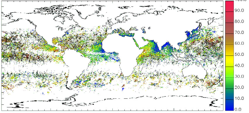
- map and establish different types of aerosols, their abundance, optical thickness and other characteristics ;
- assess the physical characteristics of vegetation cover ;
- study cloud properties ;
- map variations in concentrations of marine phytoplankton that act as a biological filter to fix carbon gases in the atmosphere.
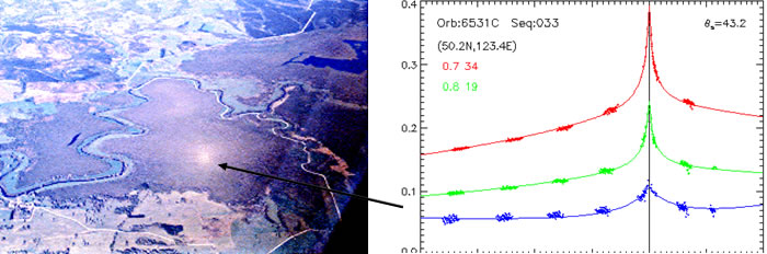
Polder is the only instrument to have acquired very dense measurements of light reflected from a surface in all directions. In particular, it has quantified the so-called “hotspot effect” whereby solar radiation is retro-reflected from Earth toward the Sun.
Processing of Polder measurements is now complete and scientists have all the data to pursue their research.
By November 2005, no fewer than 113 international scientific papers using Polder data had been published.
By November 2005, no fewer than 113 international scientific papers using Polder data had been published.

The Intertropical Zone is mostly covered by ice clouds (over Indonesia and West Africa) due to convection of cumulonimbus. Conversely, the banks of stratocumulus along the coasts of the United Kingdom and South America are correctly detected as liquid water clouds by polarized light measurements.
The mission is therefore an undisputed success, and a Polder instrument is currently flying on the Parasol satellite.
* POLarization and Directionality of Earth Reflectance
** ADvanced Earth Observation Satellite
* POLarization and Directionality of Earth Reflectance
** ADvanced Earth Observation Satellite
A few key dates
Polder 1 was launched in August 1996 on the Japanese Adeos** satellite. It transmitted data for 8 months until June 1997, when the satellite was lost after its solar array failed.
Polder 2 was launched in December 2002 on Adeos 2 and supplied data up to October 2003, when an electrical power failure terminated the mission.
Polder 2 was launched in December 2002 on Adeos 2 and supplied data up to October 2003, when an electrical power failure terminated the mission.